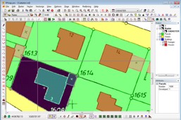

Trace polygons from maps
For area based information, such as parcels and buildings, "polygon/polyline"
tracing options provide capturing spatial data from plans and maps. With a click of the
mouse these areas can be quickly recorded along with meta data and attributes. The converted map can than be export to any GIS system by ESRI Shape files or ArcInfo MIF files.
 Application Video
These features are available in solutions of the following product groups:
These features are available in solutions of the following product groups:
| VPmap Series GIS, Mapping, FM |